Everything You Need to Know to Reach the Meeting Point
There are more than 20 take-off sites for paragliding in Gran Canaria. If you have an appointment with one of our pilots, make sure you know the name of the take-off and go to the correct location.
IMPORTANT: Read all the instructions before leaving home.
How to Avoid Confusion
Some take-offs are very close to each other. If you ask local people, you might end up in the wrong place. That’s why it’s essential to know your pilot’s name and the exact location of the take-off. Remember that the pilots are often in the air and might not be able to assist you if you get lost. PLEASE don’t call repeatedly — your pilot may be flying with another passenger. Read the instructions carefully to avoid delays or losing your booking.
The Most Popular Take-Offs
In Gran Canaria, the three most well-known take-off sites are:
- Los Giles (two different take-offs)
Giles Norte
Giles (Ladera Alta) - Las Coloradas
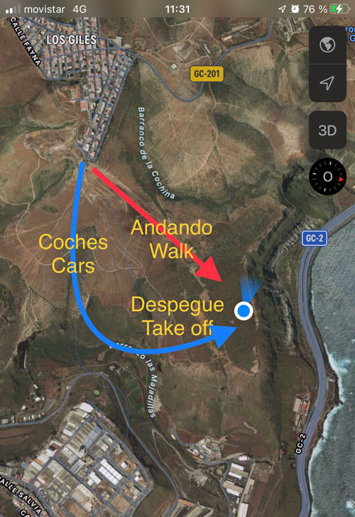
If you’re heading to Los Giles, pay extra attention — there are two take-offs in the same area. This is especially important if you’re using public transport, to avoid arriving at the wrong spot.
Giles Norte
Driving route from Las Arenas:
- When driving up from Las Palmas, take the first exit towards Costa Ayala.
- Head uphill towards Los Giles.
- Drive past the village “Ladera Alta,” continuing towards Los Giles.
- Before entering Los Giles, take the first street (you’ll see a sign for “Ferretería Rosy”). Follow that street to the end — it’s called Fray Escoba.
- At the end of the street, there’s a dirt road that leads directly to the take-off.
- The take-off is the green carpet visible at the edge of the ridge.
Note: Depending on the time of year, the dirt track may be in better or worse condition. It’s your decision whether to drive down — walking takes about 10 minutes. If it’s a hot day, bring water with you.
Still not sure? There’s a video and a map pin in the following post — it’s worth watching so you know what to expect. Video guide to Los Giles Norte take-off. Following random pins on the mountain is unreliable — reading the instructions is much safer.
Bus route (Gua Gua) from Las Arenas:
Click on “More options” on the map to check bus schedules.
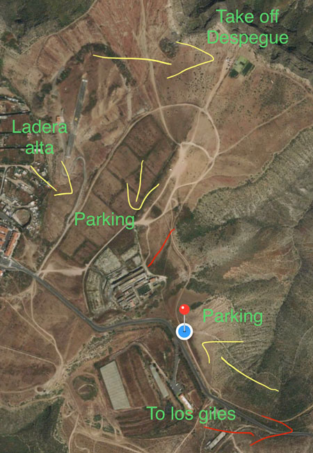
Giles (Ladera Alta)
Driving route from Las Arenas:
- When coming from Las Palmas, take the first exit towards Costa Ayala.
- Drive uphill towards Los Giles.
- Go past the village “Ladera Alta,” always following signs to Los Giles.
- Just after leaving the village, you’ll see some ruins (an old cowshed) on the left-hand side, up on the hill. Take the dirt road leading to the cowshed and continue for a few meters, then take a small turn to the left that leads to the parking area.
- Walk straight in the same direction until you see the green carpet at the edge of the ridge.
It’s very important not to block vehicle access when parking.
Another option (marked on the map) is to park in front of the community center and follow these directions from there:
Follow the dirt road with a chain across it and pass the chain on foot.
Stay on the main dirt road until you reach the take-off carpet (you won’t see it until you’re about 50 meters away).
Bus route (Gua Gua) from Las Arenas:
Click on “More options” on the map to check the schedule.
Las Coloradas
To get to Las Coloradas, follow these directions:
- Take the GC-1 motorway to the “C/ Pérez Muñoz” exit (U-turn).
- Continue along Pérez Muñoz to the end, then take Coronel Rocha street.
- Turn right to connect to the road to Las Coloradas.
- Drive to Las Coloradas, then go to the end of the village on the left side, keeping the football field on your left.
By public transport, click on “More options” on the map below or download the PDF timetable for Line 41 – Gua Guas Municipales.
Thank you for choosing Aventura en Canarias